Type or paste a URL in the input field and click on
Load URL to load KML content from the web. Loading another URL replaces the previous one. If you do not have a website where you can upload KML/KMZ files,
Google Sites is free and works well. The default URL will load Hillsborough County Benchmarks (
HCBM).
Type or paste an address in the input field and click on Fly To to search for the latitude and longitude corresponding to the given address. Placemarks may be added at geocoded positions with an eye altitude less than 200 m.
Options
Click on
Status Bar,
Navigation Control,
Scale Legend,
Grid,
Overview Map,
Atmosphere,
Sun, or
Historical Imagery to toggle visibility in the Google Earth Plugin window.
Click on Feet, Miles to toggle between metric and imperial units.
Click on Street View or Auto Street View to toggle availability.
Click on Wheel Speed to enter a value from 1.0 to 5.0 for the mouse wheel zoom speed. Use -1.0 to -5.0 to invert the zoom direction.
Click on Exaggeration to enter a value from 1.0 to 3.0 for the elevation exaggeration factor. Changing the Exaggeration value will enable the Terrain layer.
Click on Fly-To Speed to enter a value from 1.0 to 5.0.
NGS Control Stations
Click on
Off to disable NGS Control Stations.
Click on Query Setup to open an input form.
Click on Search Results to refresh the network link.
Click on View in Maps to send the current query to Google Maps. Support for this feature depends on the availability and limits of the Google Maps server. The server will not accept more than 1050 stations, and a response of "File not found" indicates a server timeout.
Click on Save As to save unedited search results as a generic KML 2.2 document. The resulting file is suitable for viewing in ESRI ArcGIS Explorer or may be imported into Google Maps My Places.
See NGSCS to learn more about NGS Control Stations.
Section Geocoder
Click on
Off to disable Section Geocoder.
Click on Point Search to refresh the network link.
Click on TRS Search to open an input form.
Click on Save As to save Section Geocoder results as a KML 2.2 document.
See PLSGE to learn more about the Section Geocoder.
Address Geocoder
Click on
Instructions to display this information in a balloon for quick reference.
Type or paste an address in the input field and click on Fly To to search for the latitude and longitude corresponding to the given address. Placemarks may be added at geocoded positions with an eye altitude less than 200 m.
Ctrl-Click on the globe to search for an address corresponding to the given latitude and longitude. Placemarks may be added at all reverse-geocoded addresses.
Shift-Click on a geocoder placemark to remove it.
Alt-Click on a geocoder placemark to edit its name and description.
Drag a geocoder placemark to change its location.
Click on Save As to save Address Geocoder placemarks as a KML 2.2 document.
Overlays
Click on
Off to disable Overlays.
Click on BLM Townships, Principal Meridians, or Special Surveys to refresh the respective network link. See PLSGE to learn more about these overlays.
Click on USGS Quad Index or USGS Topo Maps to refresh the respective network link. See QUADS to learn more about these overlays.
Click on Automatic Refresh to toggle availability.
Layers
Click on Borders, Roads, Buildings, Trees, or Terrain to toggle visibility.
File
Click on Open KML to open an input form. Then choose a local file and click Open. Opening or pasting KML will replace the previous collection of objects that were either pasted or opened.
Edit
Click on
Paste KML to open an input form. Then type or paste KML in the input area and click
Paste. Pasting or opening KML will replace the previous collection of objects that were either opened or pasted.
Click on Delete KML to open an instruction balloon for quick reference. Shift-Click on any KML geometry object to remove it.
View
Click on Loaded URL, Local KML, Addresses, or Survey Logo to toggle visibility. Local KML is the last collection of objects either pasted with Paste KML or opened with Open KML. Addresses comprises all Address Geocoder placemarks.
Help
Click on
Reference to display this web page in a new window.
Click on About to display copyright, date, and version information.
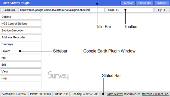
The Earth Survey Plugin Status Bar displays the Google Earth Plugin version number and window size, and the 3D viewer tilt and heading.
All images and data are retrieved from remote servers. Data errors, accuracy, and availability are beyond the control of this application.